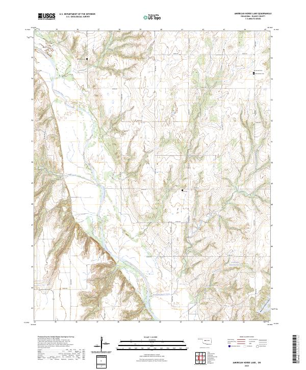
2023 Map of American Horse Lake
USGS Topo · Published 2023About this map
The Canadian River snakes through the northwestern corner of this Blaine County landscape, carving a distinct valley that defines the local drainage. To the south, the deep relief of American Horse Canyon dominates the topography, leading into the headwaters of American Horse Creek. This area is characterized by a sparse, rural grid of section roads like n2500 RD and e0880 RD, which connect several small, localized landmarks vital for genealogical research. Four distinct burial grounds, including Whirlwind Cem and Etna Cem, are scattered across the townships, indicating the distribution of early ranching and farming families. The presence of Emmanuel Cem and Macedonia Cem near the eastern boundary suggests long-standing community centers in an otherwise open prairie environment, where water features like Bear Creek and Groendyke Pond Number 1 provided essential resources for local operations.
Find a feature on this map
30 named features on this map. Tap any name to fly to it.
Don’t see what you’re looking for? This feature index may not catch every label — zoom into the map to look around manually.
Map Details
Editions of this 2023 American Horse Lake Map
This is the sole edition of this map. No revisions or reprints were ever made.
Other maps of this area

1942 · Geary
USGS Topo · 1:62,500

1955 · Clinton
USGS Topo · 1:250,000

1957 · Clinton
USGS Topo · 1:250,000

1964 · Oakwood
USGS Topo · 1:62,500

1964 · Weatherford
USGS Topo · 1:62,500

1972 · Watonga
USGS Topo · 1:24,000

1979 · Greenfield
USGS Topo · 1:24,000
1979 · Bridgeport
USGS Topo · 1:24,000
1985 · Weatherford
USGS Topo · 1:24,000
1985 · Hydro
USGS Topo · 1:24,000