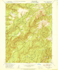
1950 Map of American House
USGS Topo · Published 1950About this map
American House sits at the junction of remote forest roads in this mid-century survey of the Plumas National Forest. The landscape is dominated by the steep drainages of the South Fork Feather River and the South Branch Middle Fork Feather River, reflecting a transitional era where early mining and ranching footprints remained visible alongside active fire suppression infrastructure. Notable landmarks include the Lexington Hill Lookout and Camel Pk Lookout, which provided vital watchpoints over the timber-rich terrain. Historical activity is documented through sites like the Browns Hill Mine (Inactive) and Sanborn Mine (Inactive), while localized habitation is noted at the McIntosh Ranch and Boehme Ranch. The map captures the rugged intersection of Plumas, Butte, Yuba, and Sierra counties, preserving the names of remote ravines and peaks before modern development or road expansion altered these forest corridors.
Find a feature on this map
48 named features on this map. Tap any name to fly to it.
Don’t see what you’re looking for? This feature index may not catch every label — zoom into the map to look around manually.
Map Details
Editions of this 1950 American House Map
2 editions found
Other maps of this area

1888 · Bidwell Bar
USGS Topo · 1:125,000

1891 · Bidwell Bar
USGS Topo · 1:125,000

1891 · Downieville
USGS Topo · 1:125,000

1893 · Bidwell Bar
USGS Topo · 1:125,000

1893 · Downieville
USGS Topo · 1:125,000

1895 · Bidwell Bar
USGS Topo · 1:125,000

1895 · Downieville
USGS Topo · 1:125,000

1896 · Downieville
USGS Topo · 1:125,000

1897 · Bidwell Bar
USGS Topo · 1:125,000

1897 · Downieville
USGS Topo · 1:125,000