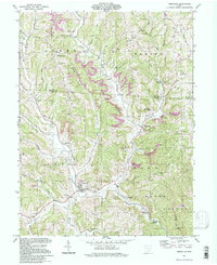
1994 Map of Amesville
USGS Topo · Published 1998About this map
The confluence of Linscott Run and Federal Creek anchors the village of Amesville, a historic settlement in the hill country of Southeast Ohio. This 1994 photo-inspection of the landscape reveals a region defined by its rugged topography and industrial history, where extensive Strip Mines mark the ridges above Joy and Sharpsburg. The map preserves the locations of numerous family and community landmarks, from the Watson Cem and Beasley Cem to the Mt Zion Cem & Ch, providing a detailed record for genealogists and local historians. Public lands such as Gifford State Forest and portions of the Wayne National Forest cover the southern and eastern sections. Notable rural infrastructure includes an Old Railroad Grade winding through the valley near Lathrop and the Mud Sock Dam on the western edge of the quadrangle.
Find a feature on this map
58 named features on this map. Tap any name to fly to it.
Don’t see what you’re looking for? This feature index may not catch every label — zoom into the map to look around manually.
Map Details
Editions of this 1994 Amesville Map
This is the sole edition of this map. No revisions or reprints were ever made.
Other maps of this area

1903 · Athens
USGS Topo · 1:62,500

1904 · Chesterhill
USGS Topo · 1:62,500

1905 · Athens
USGS Topo · 1:62,500

1906 · Chesterhill
USGS Topo · 1:62,500

1910 · Mc Connelsville
USGS Topo · 1:62,500

1911 · New Lexington
USGS Topo · 1:62,500

1947 · Columbus
USGS Topo · 1:250,000

1949 · Clarksburg
USGS Topo · 1:250,000

1956 · Clarksburg
USGS Topo · 1:250,000

1960 · Amesville
USGS Topo · 1:24,000