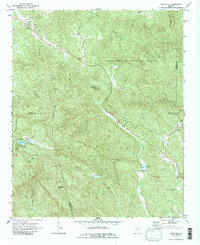
1971 Map of Amicalola
USGS Topo · Published 1987About this map
Amicalola Falls State Park and the surrounding southern Blue Ridge mountains define this 1971 topographical study. The terrain is a network of ridges and watercourses, anchored by Amicalola Mountain and the waters of Amicalola Creek. Religious life in this portion of the Chattahoochee National Forest is well-documented through numerous country churches and associated grounds, including Little Ebenezer Ch, Ebenezer Ch, and Antioch Ch. The map reveals a transition between public forest lands and private holdings along the borders of Gilmer, Dawson, and Pickens counties. Significant water features like Sequoyah Lake and Fausett Lake appear alongside family-named landmarks like Horse Cove and Eagle Br. The topography is marked by notable peaks such as Sassafras Mtn and Burnt Mtn, the latter featuring a Radio Tower that serves as a modern navigational landmark amidst the older jeep trails and secondary roads.
Find a feature on this map
30 named features on this map. Tap any name to fly to it.
Don’t see what you’re looking for? This feature index may not catch every label — zoom into the map to look around manually.
Map Details
Editions of this 1971 Amicalola Map
2 editions found
Other maps of this area

1888 · Ellijay
USGS Topo · 1:125,000

1890 · Suwanee
USGS Topo · 1:125,000

1892 · Ellijay
USGS Topo · 1:125,000

1894 · Suwanee
USGS Topo · 1:125,000

1898 · Ellijay
USGS Topo · 1:125,000

1911 · Ellijay
USGS Topo · 1:125,000

1926 · Tate
USGS Topo · 1:62,500

1928 · Tate
USGS Topo · 1:62,500

1935 · Noontootla
USGS Topo · 1:24,000

1935 · Tickanetley
USGS Topo · 1:24,000