1957 Map of Amity
USGS Topo · Published 1993About this map
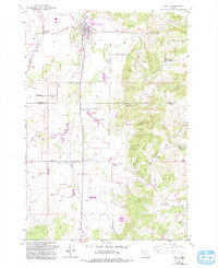
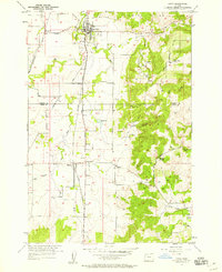
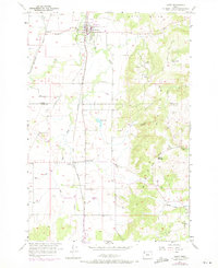
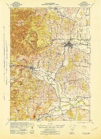
Amity anchors this 1957 survey, sitting at the junction of the Southern Pacific rail line and local highways in Yamhill County. The landscape is defined by the transition from the agricultural plains of Ash Swale and Swale Creek in the west to the elevation of the Amity Hills and the Eola Crest in the east. The map records a dense network of rural infrastructure including the Community Church at Bethel, numerous reservoirs for irrigation, and small clusters such as Finns Corner and McCoy. Notable local history markers appear throughout the area, from the Zena Cem and Landing Strip in the south to the Quarry and Eola Crest Spring tucked into the higher elevations. This edition includes purple revision data from the late 1980s, documenting modern additions like Sewage Disposal Ponds and updated road alignments while preserving the original mid-century rural character.
Find a feature on this map
42 named features on this map. Tap any name to fly to it.
Don’t see what you’re looking for? This feature index may not catch every label — zoom into the map to look around manually.
Map Details
Editions of this 1957 Amity Map
3 editions found
Other maps of this area

1915 · Rickreall
USGS Topo · 1:31,680

1915 · Eola
USGS Topo · 1:31,680

1917 · Salem
USGS Topo · 1:62,500

1924 · Mc Minnville
USGS Topo · 1:48,000

1926 · Mc Minnville
USGS Topo · 1:62,500

1940 · McMinnville
USGS Topo · 1:62,500
1940 · Salem
USGS Topo · 1:62,500

1942 · Sheridan
USGS Topo · 1:62,500
1942 · Dallas
USGS Topo · 1:62,500

1948 · Vancouver
USGS Topo · 1:250,000