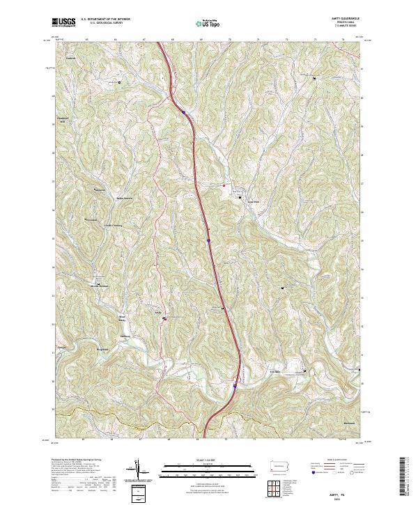
2023 Map of Amity
USGS Topo · Published 2023About this map
Amity and West Amity sit at the heart of this landscape, where the ridges of Washington County meet the Greene Co line. The terrain is defined by a dense network of streams such as Tenmile Creek and Montgomery Run, which have historically dictated the placement of settlements and transport routes. Evidence of early industry and community life is scattered throughout the hills, from Chambers Mill on the western edge to the rail-related naming of Baker Station.
Find a feature on this map
129 named features on this map. Tap any name to fly to it.
Don’t see what you’re looking for? This feature index may not catch every label — zoom into the map to look around manually.
Map Details
Editions of this 2023 Amity Map
This is the sole edition of this map. No revisions or reprints were ever made.
Other maps of this area

1901 · Amity
USGS Topo · 1:62,500

1901 · Waynesburg
USGS Topo · 1:62,500

1904 · Amity
USGS Topo · 1:62,500

1904 · Waynesburg
USGS Topo · 1:62,500

1905 · Rogersville
USGS Topo · 1:62,500

1907 · Claysville
USGS Topo · 1:62,500

1949 · Clarksburg
USGS Topo · 1:250,000

1951 · Canton
USGS Topo · 1:250,000

1953 · Canton
USGS Topo · 1:250,000
1953 · Washington East
USGS Topo · 1:24,000
Featured Places
- Morris Township, PA
- Washington Township, PA
- North Franklin Township, PA
- South Franklin Township, PA
- Condit Crossing, Amwell Township