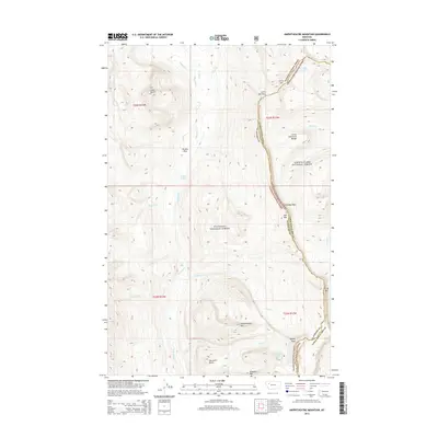
2014 Map of Amphitheatre Mountain
USGS Topo · Published 2014About this map
The Chinese Wall of the Lewis and Clark Range forms the defining geological spine of this area, marking the continental divide and the boundary between Flathead National Forest and Lewis & Clark National Forest. This high-altitude landscape is characterized by a network of drainage basins, where the White River flows southward, joined by tributaries like Rooney Cr and Pedro Cr. The terrain is punctuated by prominent summits including Amphitheatre Mtn, Moccasin Butte, and Gladiator Mtn. These peaks and basins, such as Brushy Park, illustrate the complex topography that has historically shaped travel through these mountains. Remote alpine water bodies like My Lake and Diamond Lake sit tucked within high cirques, while gaps like Larch Hill Pass indicate the natural corridors used to navigate the dramatic vertical relief of the front range.
Find a feature on this map
34 named features on this map. Tap any name to fly to it.
Don’t see what you’re looking for? This feature index may not catch every label — zoom into the map to look around manually.
Map Details
Editions of this 2014 Amphitheatre Mountain Map
This is the sole edition of this map. No revisions or reprints were ever made.
Other maps of this area

1936 · Silvertip
USGS Topo · 1:96,000

1942 · Silvertip
USGS Topo · 1:125,000

1955 · Choteau
USGS Topo · 1:250,000

1957 · Choteau
USGS Topo · 1:250,000

1958 · Choteau
USGS Topo · 1:250,000

1962 · Choteau
USGS Topo · 1:250,000

1970 · Big Salmon Lake East
USGS Topo · 1:24,000
1970 · Cathedral Peak
USGS Topo · 1:24,000
1970 · Prairie Reef
USGS Topo · 1:24,000
1970 · Haystack Mountain
USGS Topo · 1:24,000