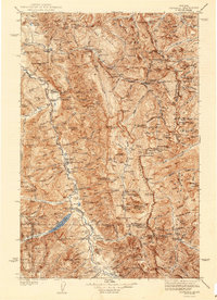
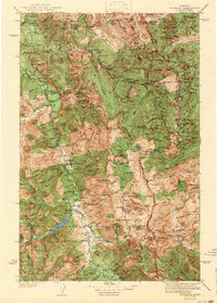
1942 Map of Silvertip
USGS Topo · Published 1942About this map
Big Prairie Ranger Sta serves as a remote hub in this high mountain landscape, anchoring a network of backcountry communications and fire management. Surveyed in 1936, the map reveals a rugged wilderness structured by primitive guard stations and essential air access points like the Black Bear Landing Field and Meadow Creek Landing Field. These landing strips, often situated along the winding courses of the South Fork Flathead River and the Spotted Bear River, were critical for supplies and rapid response in an era when heavy timber and high peaks dictated the pace of travel.
Find a feature on this map
212 named features on this map. Tap any name to fly to it.
Don’t see what you’re looking for? This feature index may not catch every label — zoom into the map to look around manually.
Map Details
Editions of this 1942 Silvertip Map
2 editions found
Other maps of this area

1902 · Ovando
USGS Topo · 1:125,000

1903 · Saypo
USGS Topo · 1:125,000

1903 · Coopers Lake
USGS Topo · 1:125,000

1905 · Ovando
USGS Topo · 1:125,000

1913 · Marias Pass
USGS Topo · 1:125,000

1914 · Nyack
USGS Topo · 1:125,000

1914 · Heart Butte
USGS Topo · 1:125,000
1918 · Heart Butte
USGS Topo · 1:125,000

1921 · Elbow Lake
USGS Topo · 1:125,000

1936 · Silvertip
USGS Topo · 1:96,000