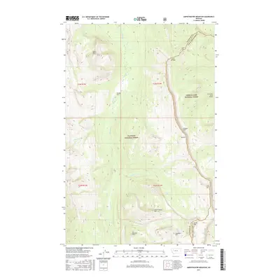
2017 Map of Amphitheatre Mountain
USGS Topo · Published 2017About this map
Amphitheatre Mtn and the striking limestone escarpment known as the Chinese Wall dominate this portion of the northern Rockies within the Flathead National Forest. This high-altitude landscape is defined by the continental divide, where the boundary between Flathead and Lewis and Clark counties follows the sharp ridgelines of the Lewis and Clark Range. The drainage patterns are clearly established by the White River, which collects water from numerous high-country tributaries such as Pagoda Cr and Cliff Cr. The map reveals a wilderness largely devoid of modern development, emphasizing natural landmarks like Larch Hill Pass and Moccasin Butte. Small, isolated water features like Oasis Pond stand out against the steep contours of the surrounding peaks, including Sphinx Peak and Gladiator Mtn.
Find a feature on this map
30 named features on this map. Tap any name to fly to it.
Don’t see what you’re looking for? This feature index may not catch every label — zoom into the map to look around manually.
Map Details
Editions of this 2017 Amphitheatre Mountain Map
This is the sole edition of this map. No revisions or reprints were ever made.
Other maps of this area

1936 · Silvertip
USGS Topo · 1:96,000

1942 · Silvertip
USGS Topo · 1:125,000

1955 · Choteau
USGS Topo · 1:250,000

1957 · Choteau
USGS Topo · 1:250,000

1958 · Choteau
USGS Topo · 1:250,000

1962 · Choteau
USGS Topo · 1:250,000

1970 · Big Salmon Lake East
USGS Topo · 1:24,000
1970 · Cathedral Peak
USGS Topo · 1:24,000
1970 · Prairie Reef
USGS Topo · 1:24,000
1970 · Haystack Mountain
USGS Topo · 1:24,000