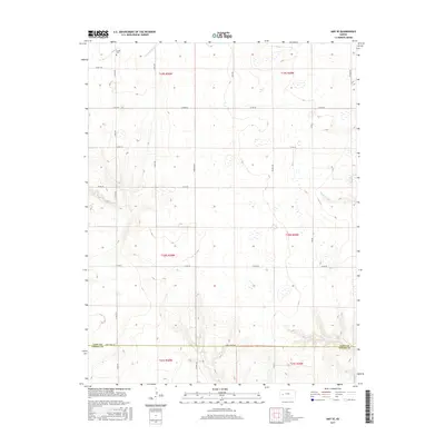
2015 Map of Amy SE
USGS Topo · Published 2015About this map
Sutton Cem sits in the northwestern corner of this landscape, marking a localized point of historical significance near the upper reaches of S Fork Walnut Cr. The terrain is defined by a grid of rural section lines and county roads, reflecting the systematic land survey patterns of western Kansas. The southern boundary of the map follows the Lane Co Finney Co line, where the aptly named Lane-Finney Rd serves as a primary east-west artery across the high plains. Seasonal drainage patterns are visible through the course of Hackberry Cr in the east and various small depressions that suggest the presence of intermittent wetlands. This area, divided by Townships 19, 20, and 21 South, maintains its agricultural character through a network of named routes including Eagle Rd, Gage Rd, and Ike Rd.
Find a feature on this map
26 named features on this map. Tap any name to fly to it.
Don’t see what you’re looking for? This feature index may not catch every label — zoom into the map to look around manually.
Map Details
Editions of this 2015 Amy SE Map
This is the sole edition of this map. No revisions or reprints were ever made.
Other maps of this area

1955 · Scott City
USGS Topo · 1:250,000

1958 · Scott City
USGS Topo · 1:250,000

1974 · Ravanna
USGS Topo · 1:24,000
1974 · Scott City 4 NW
USGS Topo · 1:24,000

1974 · Dighton SW
USGS Topo · 1:24,000

1974 · Amy SE
USGS Topo · 1:24,000

1974 · Dighton
USGS Topo · 1:24,000

1974 · Scott City 4 NE
USGS Topo · 1:24,000

1974 · Amy SW
USGS Topo · 1:24,000

1974 · Grigston
USGS Topo · 1:24,000