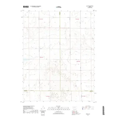
2018 Map of Amy SW
USGS Topo · Published 2018About this map
Dry Lake dominates the west-central portion of this High Plains landscape where Finney, Scott, and Lane Counties converge. This 2018 survey documents a strictly rectilinear grid of section roads and county boundaries, illustrating the modern agricultural management of the region. The map captures the intersection of several named local thoroughfares, including Arapahoe Rd, S Venison Rd, and Abilene Rd, which facilitate transport through the vast township plots of T19S, T20S, and T21S. The convergence of three counties—Scott, Lane, and Finney—is clearly delineated by boundary lines like Scott Co Lane Co and Lane Co Finney Co. This environment is defined by its subtle topographic shifts and the essential role of specialized local roads such as N Mennonite Rd and Cheyenne Rd in connecting this expansive Kansas prairie.
Find a feature on this map
31 named features on this map. Tap any name to fly to it.
Don’t see what you’re looking for? This feature index may not catch every label — zoom into the map to look around manually.
Map Details
Editions of this 2018 Amy SW Map
This is the sole edition of this map. No revisions or reprints were ever made.
Other maps of this area

1940 · Scott City
USGS Topo · 1:62,500

1944 · Tennis
USGS Topo · 1:62,500

1951 · Scott City
USGS Topo · 1:62,500

1955 · Scott City
USGS Topo · 1:250,000

1958 · Scott City
USGS Topo · 1:250,000
1974 · Scott City 4 NW
USGS Topo · 1:24,000

1974 · Amy SE
USGS Topo · 1:24,000

1974 · Scott City 4 NE
USGS Topo · 1:24,000

1974 · Amy SW
USGS Topo · 1:24,000

1974 · Grigston
USGS Topo · 1:24,000