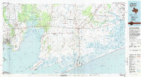
1983 Map of Anahuac
USGS Topo · Published 1983About this map
The Spindletop Oil Field and the surrounding energy landscape dominate this coastal Texas region in the early 1980s. This survey details the complex network of petroleum infrastructure and water-dependent industry stretching across Chambers County and into Jefferson and Liberty counties. From the industrial activity at Baytown to the sprawling Anahuac National Wildlife Refuge along the Gulf of Mexico, the map reveals a geography defined by the extraction economy and the ecological preservation of the coastal marshes.
Find a feature on this map
100 named features on this map. Tap any name to fly to it.
Don’t see what you’re looking for? This feature index may not catch every label — zoom into the map to look around manually.
Map Details
Editions of this 1983 Anahuac Map
2 editions found
Other maps of this area

1916 · Burnett Bay
USGS Topo · 1:24,000

1916 · Crosby
USGS Topo · 1:24,000

1916 · Morgan Point
USGS Topo · 1:24,000

1916 · Seabrook
USGS Topo · 1:24,000

1916 · Cedar Bayou
USGS Topo · 1:24,000

1916 · Huffman
USGS Topo · 1:24,000

1916 · La Porte
USGS Topo · 1:24,000

1919 · Morgan Point
USGS Topo · 1:31,680

1919 · Crosby
USGS Topo · 1:31,680

1919 · Cedar Bayou
USGS Topo · 1:31,680