
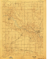
1890 Map of Anamosa
USGS Topo · Published 1890About this map
The winding Wapsipinicon River dominates this late nineteenth-century landscape, carving a deep valley through Jones and Linn Counties. The 1888 field survey by W. J. Peters captures a period of significant railway development, showing the Chicago Milwaukee and St. Paul Railroad intersecting the region. This rail network connects established settlements like Springville and Viola to the larger hub of Anamosa, where the C. and N. W. line also terminates.
Find a feature on this map
24 named features on this map. Tap any name to fly to it.
Don’t see what you’re looking for? This feature index may not catch every label — zoom into the map to look around manually.
Map Details
Editions of this 1890 Anamosa Map
2 editions found
Other maps of this area

1887 · Cedar Rapids
USGS Topo · 1:62,500

1888 · Marion
USGS Topo · 1:62,500

1889 · Tipton
USGS Topo · 1:62,500

1889 · Marion
USGS Topo · 1:62,500

1890 · Tipton
USGS Topo · 1:62,500

1891 · Monticello
USGS Topo · 1:62,500

1891 · Mechanicsville
USGS Topo · 1:62,500

1891 · Cedar Rapids
USGS Topo · 1:62,500

1894 · Mechanicsville
USGS Topo · 1:62,500

1900 · Anamosa
USGS Topo · 1:125,000