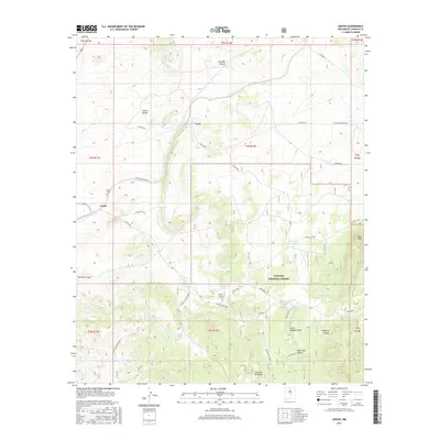
2017 Map of Ancho
USGS Topo · Published 2017About this map
Ancho sits at the western edge of the high desert landscape depicted here, positioned near the Ancho Cem and the sprawling Ancho Valley. The terrain is defined by dramatic elevation changes, rising from the valley floor toward the Jicarilla Mountains in the south and the prominent Jacks Peak to the east. This 2017 survey details a landscape where water management is central to land use, evidenced by a network of drainage features such as Ancho Rico and Ancho Gulch, as well as numerous livestock tanks like Sinks Tank and West Tank. Much of the southern portion of the map is dominated by the Lincoln National Forest, where steep canyons like Hoecradle Canyon and Hasperos Canyon carve through the foothills. The proximity of the settlement at Luna to these forest boundaries suggests a rural interface between ranching and protected public lands.
Find a feature on this map
38 named features on this map. Tap any name to fly to it.
Don’t see what you’re looking for? This feature index may not catch every label — zoom into the map to look around manually.
Map Details
Editions of this 2017 Ancho Map
This is the sole edition of this map. No revisions or reprints were ever made.
Other maps of this area

1950 · Little Black Peak
USGS Topo · 1:62,500

1954 · Fort Sumner
USGS Topo · 1:250,000

1955 · Roswell
USGS Topo · 1:250,000

1958 · Fort Sumner
USGS Topo · 1:250,000

1958 · Roswell
USGS Topo · 1:250,000

1962 · Roswell
USGS Topo · 1:250,000

1973 · Ancho
USGS Topo · 1:24,000

1973 · Chupadero Mountain
USGS Topo · 1:24,000
1973 · White Oaks North
USGS Topo · 1:24,000

1973 · Jicarilla Peak
USGS Topo · 1:24,000