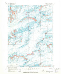
1960 Map of Anchorage B-1
USGS Topo · Published 1973About this map
Massive ice fields and high peaks dominate the Matanuska-Susitna Borough in this mid-century survey of the Chugach Mountains. The landscape is defined by the convergence of the Harvard Glacier, Yale Glacier, and the expansive Columbia Glacier. These frozen rivers flow between prominent summits including Mount Witherspoon, Mount Einstein, and Mount Valhalla, while the Dora Keen Range forms a central spine across the terrain.
Find a feature on this map
22 named features on this map. Tap any name to fly to it.
Don’t see what you’re looking for? This feature index may not catch every label — zoom into the map to look around manually.
Map Details
Editions of this 1960 Anchorage B-1 Map
2 editions found
Other maps of this area

1951 · Anchorage
USGS Topo · 1:250,000

1952 · Valdez
USGS Topo · 1:250,000

1960 · Valdez A-8
USGS Topo · 1:63,360

1960 · Anchorage A-2
USGS Topo · 1:63,360

1960 · Anchorage A-1
USGS Topo · 1:63,360

1960 · Anchorage C-2
USGS Topo · 1:63,360

1960 · Anchorage B-1
USGS Topo · 1:63,360

1960 · Anchorage B-2
USGS Topo · 1:63,360

1960 · Valdez B-8
USGS Topo · 1:63,360

1960 · Valdez C-8
USGS Topo · 1:63,360