
1960 Map of Anchorage B-2
USGS Topo · Published 1965About this map
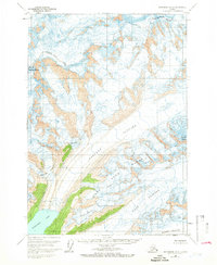
Mount Marcus Baker dominates the northwestern corner of this Chugach Mountains landscape, serving as a massive high point for an intricate system of ice fields and calving glaciers. The map details the massive confluence of the Harvard Glacier as it flows south into the deep waters of Harvard Arm. This 1960 era survey, compiled from aerial photography, captures the positions of several significant ice flows including Radcliffe Glacier, Lowell Glacier, and Downer Glacier. To the east, the Yale Glacier and Meares Glacier carve through the high peaks near Mount Glenn. The lack of any roads or trails highlights the purely glacial and alpine nature of this interior region, where topography is defined by ice contours and jagged ridges rather than human settlement.
Find a feature on this map
9 named features on this map. Tap any name to fly to it.
Don’t see what you’re looking for? This feature index may not catch every label — zoom into the map to look around manually.
Map Details
Editions of this 1960 Anchorage B-2 Map
2 editions found
Other maps of this area

1951 · Anchorage
USGS Topo · 1:250,000

1960 · Anchorage A-2
USGS Topo · 1:63,360

1960 · Anchorage A-1
USGS Topo · 1:63,360

1960 · Anchorage C-2
USGS Topo · 1:63,360

1960 · Anchorage A-3
USGS Topo · 1:63,360

1960 · Anchorage B-1
USGS Topo · 1:63,360

1960 · Anchorage C-3
USGS Topo · 1:63,360

1960 · Anchorage B-3
USGS Topo · 1:63,360

1960 · Anchorage C-1
USGS Topo · 1:63,360

1962 · Anchorage
USGS Topo · 1:250,000