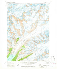
1960 Map of Anchorage B-2
USGS Topo · Published 1966About this map
Harvard Glacier and Yale Glacier dominate this glacial environment within the Matanuska-Susitna Borough as it was documented in 1960. The survey illustrates a high-altitude landscape where massive ice fields flow toward the Harvard Arm, flanked by peaks such as Mount Marcus Baker and Mount Glenn. The map provides a precise record of ice extents and crevasses before decades of significant glacial recession, showing the convergence of smaller systems like the Eliot Glacier, Radcliffe Glacier, and Baltimore Glacier into the primary trunk. Tracing the drainages of the Dora Keen Glacier and Downer Glacier, researchers can observe the complex alpine topography of the Chugach Mountains area during the mid-20th century, a time when many of these features remained unsurveyed on the ground.
Find a feature on this map
13 named features on this map. Tap any name to fly to it.
Don’t see what you’re looking for? This feature index may not catch every label — zoom into the map to look around manually.
Map Details
Editions of this 1960 Anchorage B-2 Map
2 editions found
Other maps of this area

1951 · Anchorage
USGS Topo · 1:250,000

1960 · Anchorage A-2
USGS Topo · 1:63,360

1960 · Anchorage A-1
USGS Topo · 1:63,360

1960 · Anchorage C-2
USGS Topo · 1:63,360

1960 · Anchorage A-3
USGS Topo · 1:63,360

1960 · Anchorage B-1
USGS Topo · 1:63,360

1960 · Anchorage C-3
USGS Topo · 1:63,360

1960 · Anchorage B-3
USGS Topo · 1:63,360

1960 · Anchorage B-2
USGS Topo · 1:63,360

1960 · Anchorage C-1
USGS Topo · 1:63,360