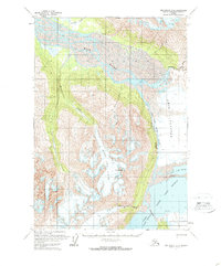
1960 Map of Anchorage B-5
USGS Topo · Published 1969About this map
Knik Glacier and its surrounding ice fields dominate this portion of the Greater Anchorage Borough, where the ice meets the complex drainage system of the Knik River. The map captures a dynamic glacial environment as it appeared in the late 1950s, characterized by the dramatic The Gorge where the Lake Fork Knik River flows. The landscape is defined by massive ice formations like Hunter Creek Glacier and Colony Glacier, which feed into the segmented waters of Inner Lake George, Upper Lake George, and Lower Lake George. High points such as Mt Palmer rise above the ice, while smaller drainages like Troublesome Creek and Friday Creek carve through the periphery of the glacial valleys. This record provides a detailed look at the ice fronts and water levels before subsequent decades of glacial retreat altered the shoreline of these alpine lakes.
Find a feature on this map
20 named features on this map. Tap any name to fly to it.
Don’t see what you’re looking for? This feature index may not catch every label — zoom into the map to look around manually.
Map Details
Editions of this 1960 Anchorage B-5 Map
3 editions found
Other maps of this area

1951 · Anchorage
USGS Topo · 1:250,000

1951 · Anchorage C-6
USGS Topo · 1:63,360

1951 · Anchorage C-5
USGS Topo · 1:63,360

1952 · Anchorage C-5
USGS Topo · 1:63,360

1960 · Anchorage A-6
USGS Topo · 1:63,360

1960 · Anchorage B-6
USGS Topo · 1:63,360

1960 · Anchorage A-5
USGS Topo · 1:63,360

1960 · Anchorage A-4
USGS Topo · 1:63,360

1960 · Anchorage C-5
USGS Topo · 1:63,360

1960 · Anchorage B-5
USGS Topo · 1:63,360