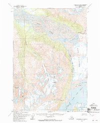
1960 Map of Anchorage B-5
USGS Topo · Published 1969About this map
Bashful Peak and Baleful Peak dominate the southwestern skyline of this 1960 survey, marking the dramatic transition from the high Chugach peaks to the glacial valleys below. The landscape is defined by the massive Knik Glacier, which feeds into the Knik River and complex water systems of Upper Lake George and Inner Lake George. These lakes are separated from the main river valley by Low Ridge, a formation that creates the distinctive bottleneck known as The Gorge.
Find a feature on this map
23 named features on this map. Tap any name to fly to it.
Don’t see what you’re looking for? This feature index may not catch every label — zoom into the map to look around manually.
Map Details
Editions of this 1960 Anchorage B-5 Map
3 editions found
Other maps of this area

1951 · Anchorage
USGS Topo · 1:250,000

1951 · Anchorage C-6
USGS Topo · 1:63,360

1951 · Anchorage C-5
USGS Topo · 1:63,360

1952 · Anchorage C-5
USGS Topo · 1:63,360

1960 · Anchorage A-6
USGS Topo · 1:63,360

1960 · Anchorage B-6
USGS Topo · 1:63,360

1960 · Anchorage A-5
USGS Topo · 1:63,360

1960 · Anchorage A-4
USGS Topo · 1:63,360

1960 · Anchorage C-5
USGS Topo · 1:63,360

1960 · Anchorage B-5
USGS Topo · 1:63,360