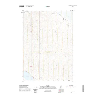
2021 Map of Anchorage B-6 NE
USGS Topo · Published 2021About this map
Pioneer Peak dominates the northern landscape of this region, standing as a primary landmark where the mountains meet the glacial waters of the Knik River. To the south, the waters of Eklutna Lake are accessible via a network of routes including the Eklutna Lakeside Trl and the Eklutna Lower Lakeside Trl, which follow the shoreline toward the Bold Ridge Trl. The map illustrates a sharp transition between the developed corridors along Knik River Road and the untamed terrain surrounding Goat Cr. This 2021 survey documents the boundary between the Matanuska-Susitna Borough and Anchorage Municipality, highlighting the interface of managed recreation trails and the natural drainage systems of the Chugach foothills.
Find a feature on this map
19 named features on this map. Tap any name to fly to it.
Don’t see what you’re looking for? This feature index may not catch every label — zoom into the map to look around manually.
Map Details
Editions of this 2021 Anchorage B-6 NE Map
This is the sole edition of this map. No revisions or reprints were ever made.
Other maps of this area

1951 · Anchorage
USGS Topo · 1:250,000

1951 · Anchorage C-6
USGS Topo · 1:63,360

1951 · Anchorage C-5
USGS Topo · 1:63,360

1952 · Anchorage C-5
USGS Topo · 1:63,360

1960 · Anchorage B-6
USGS Topo · 1:63,360

1960 · Anchorage C-5
USGS Topo · 1:63,360

1960 · Anchorage B-5
USGS Topo · 1:63,360

1962 · Anchorage
USGS Topo · 1:250,000

1979 · Anchorage B-6 NW
USGS Topo · 1:25,000
1979 · Anchorage C-6 SE
USGS Topo · 1:25,000