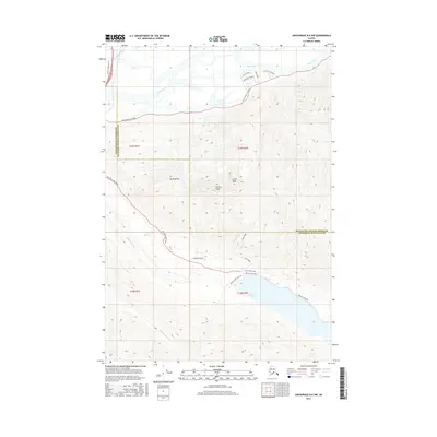
2016 Map of Anchorage B-6 NW
USGS Topo · Published 2016About this map
The confluence of the Matanuska River and Knik River dominates the northern reaches of this landscape, where the braided river channels meet the foothills of the Chugach Mountains. This 2016 survey captures the boundary between the Matanuska-Susitna Borough and Anchorage Municipality, a transition from the developing residential corridors along Wycoff Drive and Baker Boulevard to the protected wilderness of the south. High-altitude landmarks like Mt Pow/MIA, W Twin Peak, and E Twin Peak define the eastern skyline, overlooking the glacial waters of Eklutna Lake. Near the lake's western edge, the Eklutna Lake Spillway and the winding Eklutna Lakeside trail provide evidence of the area's role in local water and power infrastructure. Farther west, the path of the Eklutna River descends toward Lake Barbara, following the route traced by Eklutna Lake Road through the narrow mountain valleys.
Find a feature on this map
27 named features on this map. Tap any name to fly to it.
Don’t see what you’re looking for? This feature index may not catch every label — zoom into the map to look around manually.
Map Details
Editions of this 2016 Anchorage B-6 NW Map
This is the sole edition of this map. No revisions or reprints were ever made.
Other maps of this area

1950 · Anchorage C-7
USGS Topo · 1:63,360

1951 · Anchorage
USGS Topo · 1:250,000

1951 · Anchorage C-6
USGS Topo · 1:63,360

1951 · Anchorage C-7
USGS Topo · 1:63,360

1952 · Anchorage C-7
USGS Topo · 1:63,360

1960 · Anchorage B-7
USGS Topo · 1:63,360

1960 · Anchorage B-6
USGS Topo · 1:63,360

1962 · Anchorage
USGS Topo · 1:250,000

1979 · Anchorage B-6 NW
USGS Topo · 1:25,000
1979 · Anchorage B-7 SE
USGS Topo · 1:25,000