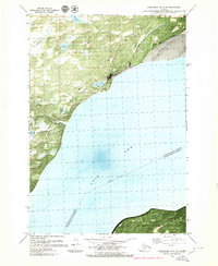
1979 Map of Anchorage B-8 NE
USGS Topo · Published 1981About this map
Knik and its surrounding wetlands sit at the heart of this late-1970s orthophotomap, showing the delicate interface where the Matanuska-Susitna Borough meets the Knik Arm of Cook Inlet. The settlement is anchored by Knik Lake and includes significant cultural markers like the Cem and Graves near the coastline. This hybrid topographic and photographic study provides a clear view of the complex hydrology of the region, featuring Threemile Creek, Goose Bay Creek, and a cluster of interior water bodies including Brocker Lake, White Lake, and Caves Lake. The terrestrial landscape is defined by the Goose Bay Road corridor and a large Gravel Pit operation, while the southern boundary is marked by the Fort Richardson Military Reservation. The map's photographic base captures the literal texture of the terrain, from the silty tidal flats of the inlet to the dense vegetation surrounding Lake Beth.
Find a feature on this map
20 named features on this map. Tap any name to fly to it.
Don’t see what you’re looking for? This feature index may not catch every label — zoom into the map to look around manually.
Map Details
Editions of this 1979 Anchorage B-8 NE Map
Other maps of this area

1950 · Anchorage C-8
USGS Topo · 1:63,360

1950 · Anchorage C-7
USGS Topo · 1:63,360

1951 · Anchorage
USGS Topo · 1:250,000

1951 · Anchorage C-7
USGS Topo · 1:63,360

1952 · Anchorage C-7
USGS Topo · 1:63,360

1952 · Anchorage C-8
USGS Topo · 1:63,360

1952 · Anchorage B-8
USGS Topo · 1:63,360

1953 · Anchorage B-8
USGS Topo · 1:63,360

1960 · Anchorage B-7
USGS Topo · 1:63,360

1962 · Anchorage
USGS Topo · 1:250,000