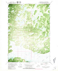
1979 Map of Anchorage B-8 NW
USGS Topo · Published 1980About this map
Goose Bay Air Force Auxiliary Field anchors the southern landscape of this 1970s orthophotomap, showing the military footprint on the edge of the Knik Arm during the Cold War era. This specialized survey blends traditional topographic contours with aerial imagery to document the intricate network of wetlands and tundra in the Matanuska-Susitna Borough. A series of interconnected water bodies, including Stephan Lake, Sevenmile Lake, and Anna Lake, dominate the northern half of the sheet, illustrating the glaciated terrain typical of this coastal region.
Find a feature on this map
23 named features on this map. Tap any name to fly to it.
Don’t see what you’re looking for? This feature index may not catch every label — zoom into the map to look around manually.
Map Details
Editions of this 1979 Anchorage B-8 NW Map
2 editions found
Other maps of this area

1949 · Tyonek
USGS Topo · 1:250,000

1950 · Anchorage C-8
USGS Topo · 1:63,360

1951 · Anchorage
USGS Topo · 1:250,000

1951 · Tyonek
USGS Topo · 1:250,000

1952 · Anchorage C-8
USGS Topo · 1:63,360

1952 · Tyonek C-1
USGS Topo · 1:63,360

1952 · Anchorage B-8
USGS Topo · 1:63,360

1953 · Anchorage B-8
USGS Topo · 1:63,360

1958 · Tyonek B-1
USGS Topo · 1:63,360

1958 · Tyonek C-1
USGS Topo · 1:63,360