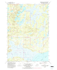
1979 Map of Anchorage B-8 NW
USGS Topo · Published 1993About this map
The Iditarod National Historic Trail winds through this coastal terrain, following a path that predates modern infrastructure. The map depicts a transitional landscape where the lowlands of the State Game Refuge meet the tidal waters of Goose Bay and the Knik Arm. While much of the area remains dominated by water bodies like Stephan Lake, Anna Lake, and Sevenmile Lake, the encroachment of the late 20th century is visible in the network of 4WD trails and the expanding reach of the Point Mackenzie Road.
Find a feature on this map
29 named features on this map. Tap any name to fly to it.
Don’t see what you’re looking for? This feature index may not catch every label — zoom into the map to look around manually.
Map Details
Editions of this 1979 Anchorage B-8 NW Map
2 editions found
Other maps of this area

1949 · Tyonek
USGS Topo · 1:250,000

1950 · Anchorage C-8
USGS Topo · 1:63,360

1951 · Anchorage
USGS Topo · 1:250,000

1951 · Tyonek
USGS Topo · 1:250,000

1952 · Anchorage C-8
USGS Topo · 1:63,360

1952 · Tyonek C-1
USGS Topo · 1:63,360

1952 · Anchorage B-8
USGS Topo · 1:63,360

1953 · Anchorage B-8
USGS Topo · 1:63,360

1958 · Tyonek B-1
USGS Topo · 1:63,360

1958 · Tyonek C-1
USGS Topo · 1:63,360