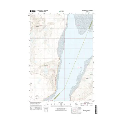
2015 Map of Anchorage B-8 SW
USGS Topo · Published 2015About this map
Point Mackenzie serves as the focal point of this coastal survey, where the glacial legacy of the Elmendorf Moraine meets the waters of Knik Arm. The landscape is defined by its aviation and military importance, featuring Elmendorf Air Force Base on the eastern shore and private landing fields like Mac Kenzie Country Airpark and Sleepers Strip to the west. Local roads such as Point McKenzie Road and Rex Bell Road navigate a terrain dotted with numerous small water bodies, including Lake Lorraine, Sixmile Lake, and Tuomi Lake. This map reveals a specialized settlement pattern where aviation infrastructure is deeply integrated into the residential and military geography of the Matanuska-Susitna Borough.
Find a feature on this map
28 named features on this map. Tap any name to fly to it.
Don’t see what you’re looking for? This feature index may not catch every label — zoom into the map to look around manually.
Map Details
Editions of this 2015 Anchorage B-8 SW Map
This is the sole edition of this map. No revisions or reprints were ever made.
Other maps of this area

1949 · Tyonek
USGS Topo · 1:250,000

1951 · Anchorage
USGS Topo · 1:250,000

1951 · Tyonek
USGS Topo · 1:250,000

1951 · Tyonek A-1
USGS Topo · 1:63,360

1952 · Tyonek A-1
USGS Topo · 1:63,360

1952 · Anchorage A-8
USGS Topo · 1:63,360

1952 · Anchorage B-8
USGS Topo · 1:63,360

1953 · Anchorage A-8
USGS Topo · 1:63,360

1953 · Anchorage B-8
USGS Topo · 1:63,360

1958 · Tyonek B-1
USGS Topo · 1:63,360