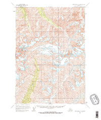
1960 Map of Anchorage C-4
USGS Topo · Published 1965About this map
The Metal Creek Glacier dominates the central landscape of this 1960 survey, serving as the massive headwater source for the drainages that carve through the Chugach Mountains. The glacial flow feeds directly into Metal Creek, which runs south through a broad valley floor, while secondary systems like Cottonwood Creek contribute to the complex hydrologic network of the Matanuska-Susitna region. In the northern reaches, the names Coal Creek and Carbon Creek suggest the mineral potential and geological composition that historically drew interest to this part of Alaska.
Find a feature on this map
14 named features on this map. Tap any name to fly to it.
Don’t see what you’re looking for? This feature index may not catch every label — zoom into the map to look around manually.
Map Details
Editions of this 1960 Anchorage C-4 Map
3 editions found

Other maps of this area

1948 · Anchorage D-3
USGS Topo · 1:63,360

1948 · Anchorage D-4
USGS Topo · 1:63,360

1949 · Anchorage D-5
USGS Topo · 1:63,360

1951 · Anchorage
USGS Topo · 1:250,000

1951 · Anchorage C-5
USGS Topo · 1:63,360

1952 · Anchorage D-5
USGS Topo · 1:63,360

1952 · Anchorage D-4
USGS Topo · 1:63,360

1952 · Anchorage D-3
USGS Topo · 1:63,360

1952 · Anchorage C-5
USGS Topo · 1:63,360

1960 · Anchorage C-5
USGS Topo · 1:63,360