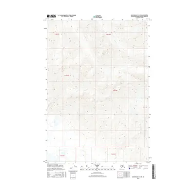
2016 Map of Anchorage C-5 SW
USGS Topo · Published 2016About this map
Glacial drainages and steep elevation shifts characterize this 2016 survey of the Matanuska-Susitna Borough. The landscape is defined by the hydrologic signatures of Jim Cr and Wolverine Cr, which carve through the northern sections of the sheet. To the south, Friday Cr emerges from the high country, illustrating the dramatic relief of the Chugach Mountains foothills. This map documents the area's complex topography and public land survey system grid, including the convergence of Townships 16, 17, and 18 North within Ranges 3 and 4 East. The lack of established road infrastructure or named settlements emphasizes the undeveloped character of this Alaskan terrain, where natural watercourses remain the primary geographic identifiers.
Find a feature on this map
9 named features on this map. Tap any name to fly to it.
Don’t see what you’re looking for? This feature index may not catch every label — zoom into the map to look around manually.
Map Details
Editions of this 2016 Anchorage C-5 SW Map
This is the sole edition of this map. No revisions or reprints were ever made.
Other maps of this area

1951 · Anchorage
USGS Topo · 1:250,000

1951 · Anchorage C-6
USGS Topo · 1:63,360

1951 · Anchorage C-5
USGS Topo · 1:63,360

1952 · Anchorage C-5
USGS Topo · 1:63,360

1960 · Anchorage B-6
USGS Topo · 1:63,360

1960 · Anchorage C-5
USGS Topo · 1:63,360

1960 · Anchorage B-5
USGS Topo · 1:63,360

1962 · Anchorage
USGS Topo · 1:250,000
1979 · Anchorage C-6 SE
USGS Topo · 1:25,000
1979 · Anchorage C-6 NE
USGS Topo · 1:25,000