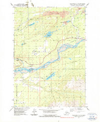
1979 Map of Anchorage C-6 NE
USGS Topo · Published 1979About this map
The industrial coal-mining landscape of Wishbone Hill and the town of Sutton define this portion of the Matanuska Valley during the late 1970s. The map captures an era where active extraction and historical infrastructure overlapped, showing the Strip Mine operations to the north and various subterranean sites like the Jonesville Mine, Buffalo Mine, and the curiously named Matanuska Sinner Mine. These mining operations are tied together by the Old Railroad Grade and the Glenn Highway, tracing the movement of resources through the valley.
Find a feature on this map
29 named features on this map. Tap any name to fly to it.
Don’t see what you’re looking for? This feature index may not catch every label — zoom into the map to look around manually.
Map Details
Editions of this 1979 Anchorage C-6 NE Map
Other maps of this area

1949 · Anchorage D-5
USGS Topo · 1:63,360

1950 · Anchorage D-6
USGS Topo · 1:63,360

1951 · Anchorage
USGS Topo · 1:250,000

1951 · Anchorage C-6
USGS Topo · 1:63,360

1951 · Anchorage C-5
USGS Topo · 1:63,360

1952 · Anchorage D-6
USGS Topo · 1:63,360

1952 · Anchorage D-5
USGS Topo · 1:63,360

1952 · Anchorage C-5
USGS Topo · 1:63,360

1960 · Anchorage C-5
USGS Topo · 1:63,360

1962 · Anchorage
USGS Topo · 1:250,000