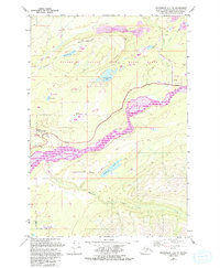
1979 Map of Anchorage C-6 NE
USGS Topo · Published 1993About this map
The Matanuska River flows through the heart of this Alaskan landscape, defining the transition between the valley floor and the rising slopes of Wishbone Hill. Recorded in the late 1970s with updates into the early 1990s, the map documents the industrial and civic development of the Matanuska Valley State Moose Range. To the north, evidence of coal extraction is visible at the Strip Mine and the historical Jonesville (Site). Settlement patterns are concentrated near the Glenn Highway, including the community of Sutton and the Palmer State Correctional Center. Transportation history is embedded in the terrain through an Old Railroad Grade that parallels the river, tracing the path of former rail lines that once connected these mining and timber areas. Numerous alpine lakes such as Wolverine Lake, Wishbone Lake, and Seventeenmile Lake dot the elevations above the river basin.
Find a feature on this map
30 named features on this map. Tap any name to fly to it.
Don’t see what you’re looking for? This feature index may not catch every label — zoom into the map to look around manually.
Map Details
Editions of this 1979 Anchorage C-6 NE Map
Other maps of this area

1949 · Anchorage D-5
USGS Topo · 1:63,360

1950 · Anchorage D-6
USGS Topo · 1:63,360

1951 · Anchorage
USGS Topo · 1:250,000

1951 · Anchorage C-6
USGS Topo · 1:63,360

1951 · Anchorage C-5
USGS Topo · 1:63,360

1952 · Anchorage D-6
USGS Topo · 1:63,360

1952 · Anchorage D-5
USGS Topo · 1:63,360

1952 · Anchorage C-5
USGS Topo · 1:63,360

1960 · Anchorage C-5
USGS Topo · 1:63,360

1962 · Anchorage
USGS Topo · 1:250,000