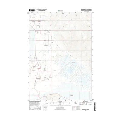
2016 Map of Anchorage C-6 SE
USGS Topo · Published 2016About this map
The glacial valley of the Knik River and Matanuska River comes into sharp focus in this topographic study of the Butte area. The landscape is defined by the prominent heights of Bodenburg Butte and Burnt Butte, which stand as landmarks above the surrounding wetlands and braided river channels. Human settlement is concentrated in the northwestern quadrant, where a dense network of roads like Maud Road and Smith Road connects local residences with facilities such as Eagle Nest Airport and Valley Memory Garden.
Find a feature on this map
72 named features on this map. Tap any name to fly to it.
Don’t see what you’re looking for? This feature index may not catch every label — zoom into the map to look around manually.
Map Details
Editions of this 2016 Anchorage C-6 SE Map
This is the sole edition of this map. No revisions or reprints were ever made.
Other maps of this area

1951 · Anchorage
USGS Topo · 1:250,000

1951 · Anchorage C-6
USGS Topo · 1:63,360

1951 · Anchorage C-5
USGS Topo · 1:63,360

1952 · Anchorage C-5
USGS Topo · 1:63,360

1960 · Anchorage B-6
USGS Topo · 1:63,360

1960 · Anchorage C-5
USGS Topo · 1:63,360

1960 · Anchorage B-5
USGS Topo · 1:63,360

1962 · Anchorage
USGS Topo · 1:250,000

1979 · Anchorage B-6 NW
USGS Topo · 1:25,000
1979 · Anchorage C-6 SE
USGS Topo · 1:25,000