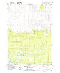
1979 Map of Anchorage C-7 NW
USGS Topo · Published 1979About this map
The Little Susitna River winds through the southern portion of this landscape, anchoring a region defined by its numerous small water bodies and emerging road network during the late 1970s. The area known as Meadow Lakes is dotted with names like Totuck Lake, Island Lake, Jaland Lake, and June Lake, reflecting a glacial terrain transitioning from wetlands to higher elevations. Transportation in this era is represented by arterial routes such as Pittman Road, Schrock Road, and Church Road, alongside a localized Landing Strip indicative of Alaska's aviation-dependent infrastructure.
Find a feature on this map
18 named features on this map. Tap any name to fly to it.
Don’t see what you’re looking for? This feature index may not catch every label — zoom into the map to look around manually.
Map Details
Editions of this 1979 Anchorage C-7 NW Map
2 editions found
Other maps of this area

1949 · Anchorage D-7
USGS Topo · 1:63,360

1949 · Anchorage D-8
USGS Topo · 1:63,360

1950 · Anchorage C-8
USGS Topo · 1:63,360

1950 · Anchorage C-7
USGS Topo · 1:63,360

1951 · Anchorage
USGS Topo · 1:250,000

1951 · Anchorage C-7
USGS Topo · 1:63,360

1951 · Anchorage D-8
USGS Topo · 1:63,360

1951 · Anchorage D-7
USGS Topo · 1:63,360

1952 · Anchorage C-7
USGS Topo · 1:63,360

1952 · Anchorage D-7
USGS Topo · 1:63,360