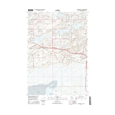
2016 Map of Anchorage C-7 SE
USGS Topo · Published 2016About this map
Wasilla Lake and the surrounding Matanuska-Susitna valley show a landscape defined by an extensive network of private airfields and residential development. This modern survey details the significant aviation infrastructure of the area, featuring specialized landing grounds like the St John Homestead Airport, Anderson Lake Airport, and the B & B Boys Ranch Airport. The community of Gateway sits at the junction of major transit corridors, while the Sacred Heart Cem provides a point of genealogical interest for local families. Natural features are dominated by the glacial lake systems, including Cottonwood Lake and Finger Lake, which feed into the meandering Cottonwood Creek. In the southern portion of the quadrangle, the terrain opens into the Duck Flats, illustrating the transition from the developed ridges near Mcdonald Ridge to the tidal wetlands of the Knik Arm.
Find a feature on this map
88 named features on this map. Tap any name to fly to it.
Don’t see what you’re looking for? This feature index may not catch every label — zoom into the map to look around manually.
Map Details
Editions of this 2016 Anchorage C-7 SE Map
This is the sole edition of this map. No revisions or reprints were ever made.
Other maps of this area

1950 · Anchorage C-7
USGS Topo · 1:63,360

1951 · Anchorage
USGS Topo · 1:250,000

1951 · Anchorage C-6
USGS Topo · 1:63,360

1951 · Anchorage C-7
USGS Topo · 1:63,360

1952 · Anchorage C-7
USGS Topo · 1:63,360

1960 · Anchorage B-7
USGS Topo · 1:63,360

1960 · Anchorage B-6
USGS Topo · 1:63,360

1962 · Anchorage
USGS Topo · 1:250,000

1979 · Anchorage B-6 NW
USGS Topo · 1:25,000
1979 · Anchorage C-7 NW
USGS Topo · 1:25,000