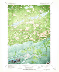
1979 Map of Anchorage C-7 SE
USGS Topo · Published 1980About this map
Wasilla serves as the focal point of this orthophotomap, which blends traditional topographic contours with aerial imagery to reveal the rapid development of the Matanuska-Susitna Valley. The town's grid is established between the Alaska Railroad and Wasilla Lake, showing the footprint of the Iditarod School and local seaplane bases. To the south, the landscape shifts toward the tidal marshes of Duck Flats and the intricate channels of Palmer Slough near the mouth of the Matanuska River.
Find a feature on this map
40 named features on this map. Tap any name to fly to it.
Don’t see what you’re looking for? This feature index may not catch every label — zoom into the map to look around manually.
Map Details
Editions of this 1979 Anchorage C-7 SE Map
This is the sole edition of this map. No revisions or reprints were ever made.
Other maps of this area

1950 · Anchorage C-7
USGS Topo · 1:63,360

1951 · Anchorage
USGS Topo · 1:250,000

1951 · Anchorage C-6
USGS Topo · 1:63,360

1951 · Anchorage C-7
USGS Topo · 1:63,360

1952 · Anchorage C-7
USGS Topo · 1:63,360

1960 · Anchorage B-7
USGS Topo · 1:63,360

1960 · Anchorage B-6
USGS Topo · 1:63,360

1962 · Anchorage
USGS Topo · 1:250,000

1979 · Anchorage B-6 NW
USGS Topo · 1:25,000
1979 · Anchorage C-7 NW
USGS Topo · 1:25,000