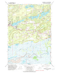
1992 Map of Anchorage C-7 SE
USGS Topo · Published 1992About this map
Wasilla serves as the focal point of this 1992 revision, showing the community's mid-century expansion along the Alaska Railroad and the George Parks Highway. The landscape is defined by its glacial hydrology, with Wasilla Lake and Finger Lake anchoring the residential and recreational corridors. Significant institutional land use is evident at the University of Alaska Experimental Farm, while local education is represented by the Iditarod Sch and Wasilla High Sch. To the south, the terrain transitions into the expansive wetlands of the Palmer State Game Refuge and the Hay Flats, where Rabbit Slough and Duck Lake mark a shift from suburban development to protected wildlife habitat. The presence of numerous gravel pits and the Seaplane Base on Finger Lake reflect the industrial and transport needs of the Matanuska-Susitna region during this era.
Find a feature on this map
58 named features on this map. Tap any name to fly to it.
Don’t see what you’re looking for? This feature index may not catch every label — zoom into the map to look around manually.
Map Details
Editions of this 1992 Anchorage C-7 SE Map
This is the sole edition of this map. No revisions or reprints were ever made.
Other maps of this area

1950 · Anchorage C-7
USGS Topo · 1:63,360

1951 · Anchorage
USGS Topo · 1:250,000

1951 · Anchorage C-6
USGS Topo · 1:63,360

1951 · Anchorage C-7
USGS Topo · 1:63,360

1952 · Anchorage C-7
USGS Topo · 1:63,360

1960 · Anchorage B-7
USGS Topo · 1:63,360

1960 · Anchorage B-6
USGS Topo · 1:63,360

1962 · Anchorage
USGS Topo · 1:250,000

1979 · Anchorage B-6 NW
USGS Topo · 1:25,000
1979 · Anchorage C-7 NW
USGS Topo · 1:25,000