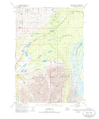
1948 Map of Anchorage D-1
USGS Topo · Published 1986About this map
Eureka Roadhouse stands as a primary waypoint along the Glenn Highway in this 1948 topographic study of the Matanuska-Susitna region. The landscape is defined by the high-altitude transition between the Matanuska River drainage and the Nelchina River basin, centered on the strategic corridor of Tahneta Pass. Evidence of mid-century infrastructure is visible in the scattered Landing Strips and a Radio Facility near Knob Lake, reflecting the era's reliance on aviation and telecommunications to bridge this interior terrain. A network of primitive routes, including a Tractor Trail near Startup Creek, suggests a landscape still largely accessed by seasonal paths and specialized machinery. Numerous alpine water bodies such as Lake Leila, Hunter Lake, and Shallow Lake are documented alongside notable heights like Table Mtn and Belanger Pass.
Find a feature on this map
39 named features on this map. Tap any name to fly to it.
Don’t see what you’re looking for? This feature index may not catch every label — zoom into the map to look around manually.
Map Details
Editions of this 1948 Anchorage D-1 Map
4 editions found
Other maps of this area

1948 · Anchorage D-2
USGS Topo · 1:63,360

1948 · Anchorage D-1
USGS Topo · 1:63,360

1949 · Talkeetna Mountains A-1
USGS Topo · 1:63,360

1949 · Gulkana A-6
USGS Topo · 1:63,360

1949 · Valdez D-8
USGS Topo · 1:63,360

1950 · Talkeetna Mountains
USGS Topo · 1:250,000

1951 · Gulkana
USGS Topo · 1:250,000

1951 · Anchorage
USGS Topo · 1:250,000

1951 · Anchorage D-1
USGS Topo · 1:63,360

1952 · Valdez D-8
USGS Topo · 1:63,360