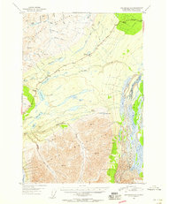
1951 Map of Anchorage D-1
USGS Topo · Published 1959About this map
Eureka Roadhouse serves as a primary waypoint along the Glenn Highway as it traverses the high-altitude pass between the Talkeetna Mountains and the northern Chugach Mountains. This mid-century survey captures a landscape defined by the transition from the Old Glenn Highway to its more modern alignment, supported by a remote Airstrip and several Tractor Trails that penetrate the mountain valleys. The drainage systems are clearly delineated, showing how the Matanuska River and the braided Nelchina River divide the geography. Local features like Tahnetta Pass and Belanger Pass highlight the historical routes taken through this difficult terrain. Researchers will find numerous benchmark locations, such as Mile 130 and Mile 120, providing precise orientation for the era's road infrastructure and small outposts like a lone Cabin near the highway.
Find a feature on this map
53 named features on this map. Tap any name to fly to it.
Don’t see what you’re looking for? This feature index may not catch every label — zoom into the map to look around manually.
Map Details
Editions of this 1951 Anchorage D-1 Map
3 editions found
Other maps of this area

1948 · Anchorage D-2
USGS Topo · 1:63,360

1948 · Anchorage D-1
USGS Topo · 1:63,360

1949 · Talkeetna Mountains A-1
USGS Topo · 1:63,360

1949 · Gulkana A-6
USGS Topo · 1:63,360

1949 · Valdez D-8
USGS Topo · 1:63,360

1950 · Talkeetna Mountains
USGS Topo · 1:250,000

1951 · Gulkana
USGS Topo · 1:250,000

1951 · Anchorage
USGS Topo · 1:250,000

1951 · Anchorage D-1
USGS Topo · 1:63,360

1952 · Valdez D-8
USGS Topo · 1:63,360