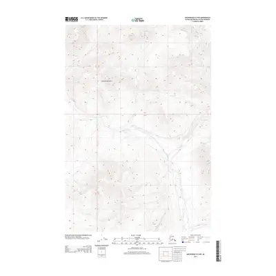
2013 Map of Anchorage D-2 NW
USGS Topo · Published 2013About this map
The Talkeetna Mountains define the high-elevation terrain of this Alaska interior landscape, where a dense network of high-latitude waterways carves through the topography. Central to the drainage system is Caribou Cr, which collects various tributaries including Mouse Cr and Alfred Cr as they flow through the deep valleys of the Matanuska-Susitna region. The map reveals a land defined almost entirely by its hydrology and relief, with named features such as Billy Cr, Sheep Cr, and Flume Cr marking the northern reaches. This 2013 survey provides a clear view of the natural corridors used by hunters and backcountry travelers, including the remote stretches of Fortress Cr and Divide Cr far from established settlements.
Find a feature on this map
12 named features on this map. Tap any name to fly to it.
Don’t see what you’re looking for? This feature index may not catch every label — zoom into the map to look around manually.
Map Details
Editions of this 2013 Anchorage D-2 NW Map
This is the sole edition of this map. No revisions or reprints were ever made.
Other maps of this area

1948 · Anchorage D-3
USGS Topo · 1:63,360

1948 · Anchorage D-2
USGS Topo · 1:63,360

1950 · Talkeetna Mountains
USGS Topo · 1:250,000

1951 · Anchorage
USGS Topo · 1:250,000

1951 · Talkeetna Mountains A-2
USGS Topo · 1:63,360

1952 · Anchorage D-2
USGS Topo · 1:63,360

1952 · Anchorage D-3
USGS Topo · 1:63,360
1952 · Talkeetna Mountains A-2
USGS Topo · 1:63,360

1954 · Talkeetna Mountains
USGS Topo · 1:250,000
1957 · Talkeetna Mountains
USGS Topo · 1:250,000