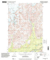
1994 Map of Anchorage D-5
USGS Topo · Published 2002About this map
The Talkeetna Mountains dominate this 1994 topographic study, where the landscape transitions from high alpine peaks to the riparian corridors of the Matanuska Valley. The southern edge of the map is defined by the heavy flow of the Matanuska River and the route of the Glenn Highway, which provides the primary access through this corridor. To the north, the terrain rises sharply toward Castle Mountain and Lava Mountain, intersected by the significant drainage of the Kings River. This area, part of the Moose Range, shows early resource exploration and recreation patterns, noted by a Mine, a Landing Strip, and Cabins tucked near Fish Lake. Smaller water bodies like Ruby Lake and Thirtymile Lake are scattered across the lower elevations, highlighting the intricate drainage network of Tract A before the elevation climbs toward Kings Mtn.
Find a feature on this map
32 named features on this map. Tap any name to fly to it.
Don’t see what you’re looking for? This feature index may not catch every label — zoom into the map to look around manually.
Map Details
Editions of this 1994 Anchorage D-5 Map
This is the sole edition of this map. No revisions or reprints were ever made.
Other maps of this area

1948 · Anchorage D-4
USGS Topo · 1:63,360

1949 · Anchorage D-5
USGS Topo · 1:63,360

1949 · Talkeetna Mountains A-4
USGS Topo · 1:63,360

1950 · Talkeetna Mountains
USGS Topo · 1:250,000

1950 · Anchorage D-6
USGS Topo · 1:63,360

1951 · Anchorage
USGS Topo · 1:250,000

1951 · Anchorage C-6
USGS Topo · 1:63,360

1951 · Anchorage C-5
USGS Topo · 1:63,360

1951 · Talkeetna Mountains A-3
USGS Topo · 1:63,360

1952 · Anchorage D-6
USGS Topo · 1:63,360