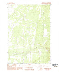
1983 Map of Anchorage D-8 SW
USGS Topo · Published 1983About this map
Willow Creek flows through this Matanuska-Susitna landscape, providing a primary drainage route as it winds past industrial activity and early transport routes. In the early 1980s, the area's geography was defined by its watercourses, including Iron Creek and Rogers Creek, which intersect the terrain near several Gravel Pits. The presence of a Foot Bridge and the Winter Trail indicates the seasonal and functional nature of movement through this region, where crossings were vital for local access.
Find a feature on this map
11 named features on this map. Tap any name to fly to it.
Don’t see what you’re looking for? This feature index may not catch every label — zoom into the map to look around manually.
Map Details
Editions of this 1983 Anchorage D-8 SW Map
This is the sole edition of this map. No revisions or reprints were ever made.
Other maps of this area

1949 · Tyonek
USGS Topo · 1:250,000

1949 · Anchorage D-8
USGS Topo · 1:63,360

1950 · Anchorage C-8
USGS Topo · 1:63,360

1951 · Anchorage
USGS Topo · 1:250,000

1951 · Tyonek
USGS Topo · 1:250,000

1951 · Anchorage D-8
USGS Topo · 1:63,360

1952 · Anchorage C-8
USGS Topo · 1:63,360

1952 · Tyonek D-1
USGS Topo · 1:63,360

1952 · Tyonek C-1
USGS Topo · 1:63,360

1952 · Anchorage D-8
USGS Topo · 1:63,360