
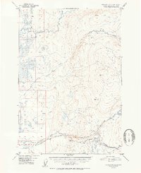
1952 Map of Anchorage D-8
USGS Topo · Published 1952About this map
Kashwitna River and its northern tributaries dominate the high-elevation landscape in this early 1950s survey of the Talkeetna Mountains region. The map reveals a wild, sparsely settled interior where transportation was dictated by the seasons and the terrain. A prominent Sled Road follows the lower reaches of Willow Creek, suggesting the importance of winter transit for those moving through the river valleys. Evidence of human presence is minimal, limited to isolated structures like the Cabin found near the confluence of Purches Creek. The topography transitions from the low-lying drainage basins of Deception Creek and Rogers Creek in the west to significant peaks in the east, identified by survey points such as VABM 3168 Willow and VABM 2450 Kash.
Find a feature on this map
13 named features on this map. Tap any name to fly to it.
Don’t see what you’re looking for? This feature index may not catch every label — zoom into the map to look around manually.
Map Details
Editions of this 1952 Anchorage D-8 Map
2 editions found
Other maps of this area

1949 · Tyonek
USGS Topo · 1:250,000

1949 · Anchorage D-7
USGS Topo · 1:63,360

1949 · Anchorage D-8
USGS Topo · 1:63,360

1950 · Talkeetna Mountains
USGS Topo · 1:250,000

1950 · Talkeetna
USGS Topo · 1:250,000

1950 · Anchorage C-8
USGS Topo · 1:63,360

1950 · Anchorage C-7
USGS Topo · 1:63,360

1950 · Talkeetna Mountains A-6
USGS Topo · 1:63,360

1951 · Talkeetna
USGS Topo · 1:250,000

1951 · Anchorage
USGS Topo · 1:250,000