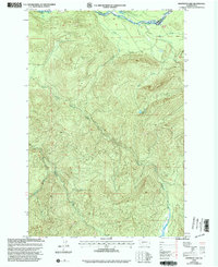
1998 Map of Anderson Lake
USGS Topo · Published 2003About this map
The Nisqually River flows through the northern reaches of this mountainous landscape, marking a portion of the boundary between Pierce and Lewis counties. In the high elevations of the late 1990s, the terrain is defined by a dense network of drainages and named summits, including the secluded Anderson Lake and the various branches of the river system. The presence of a Communication Tower on a high ridge indicates the modern infrastructure necessary for this remote terrain, while the steep grades are carved by water bodies such as North Fork Mineral Creek, Gallup Creek, and Ruby Creek. The map reflects a landscape primarily shaped by natural topography and water flow rather than dense human settlement, typical of the high-country forest lands in the Pacific Northwest at the end of the century.
Find a feature on this map
11 named features on this map. Tap any name to fly to it.
Don’t see what you’re looking for? This feature index may not catch every label — zoom into the map to look around manually.
Map Details
Editions of this 1998 Anderson Lake Map
This is the sole edition of this map. No revisions or reprints were ever made.
Other maps of this area

1924 · Mt Rainier
USGS Topo · 1:96,000

1928 · Mt Rainier
USGS Topo · 1:125,000

1937 · Eatonville
USGS Topo · 1:125,000

1950 · Yakima
USGS Topo · 1:250,000

1953 · Hoquiam
USGS Topo · 1:250,000

1956 · Mineral
USGS Topo · 1:62,500

1956 · Kapowsin
USGS Topo · 1:62,500

1957 · Hoquiam
USGS Topo · 1:250,000

1958 · Yakima
USGS Topo · 1:250,000

1958 · Hoquiam
USGS Topo · 1:250,000