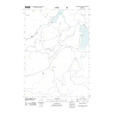
2011 Map of Anderson Ranch Dam
USGS Topo · Published 2011About this map
The Anderson Ranch Dam controls the flow of the South Fork Boise River in this rugged section of Elmore County, creating the expansive Anderson Ranch Reservoir. The map reveals the infrastructure of water management and local settlement, including Reclamation Village and the small community of Dixie. This area's industrial past is marked by mineral extractions at the Daley Con Mines and Reber Mine, located along the river and its tributaries.
Find a feature on this map
30 named features on this map. Tap any name to fly to it.
Don’t see what you’re looking for? This feature index may not catch every label — zoom into the map to look around manually.
Map Details
Editions of this 2011 Anderson Ranch Dam Map
This is the sole edition of this map. No revisions or reprints were ever made.
Other maps of this area

1892 · Mountain Home
USGS Topo · 1:125,000

1892 · Camas Prairie
USGS Topo · 1:125,000

1893 · Mountain Home
USGS Topo · 1:125,000

1893 · Camas Prairie
USGS Topo · 1:125,000

1955 · Hailey
USGS Topo · 1:250,000

1956 · Mountain Home
USGS Topo · 1:62,500
1958 · Bennett Mtn
USGS Topo · 1:62,500

1959 · Hailey
USGS Topo · 1:250,000

1960 · Danskin Peak
USGS Topo · 1:62,500

1962 · Hailey
USGS Topo · 1:250,000