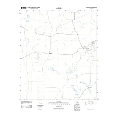
2011 Map of Andersonville
USGS Topo · Published 2011About this map
Andersonville and its surrounding countryside are defined by a complex network of creeks and small impoundments, reflecting the agricultural and memorial landscape of Sumter County. The town is flanked by significant sites of remembrance, including the Andersonville National Cemetery and the local Andersonville Cemetery. This 2011 survey reveals the hydrological structure of the area, where Prison Branch flows toward the town while Sweetwater Creek and Triple Creek drain the broader terrain. Several family-named or local water bodies such as Wohlwender Lake, Charles Reeves Lake, and Tharpe Lake point to a landscape managed for farming and water resources. To the west, smaller settlements like La Crosse and Bumphead appear along the rural road network, connected by routes like La Crosse Rd and Bumphead Rd. This map provides a detailed view of the modern boundaries and landmarks of a region with deep roots in Georgia's history.
Find a feature on this map
51 named features on this map. Tap any name to fly to it.
Don’t see what you’re looking for? This feature index may not catch every label — zoom into the map to look around manually.
Map Details
Editions of this 2011 Andersonville Map
This is the sole edition of this map. No revisions or reprints were ever made.
Other maps of this area

1955 · Phenix City
USGS Topo · 1:250,000

1957 · Phenix City
USGS Topo · 1:250,000

1958 · Phenix City
USGS Topo · 1:250,000

1971 · Ideal South
USGS Topo · 1:24,000

1971 · Ellaville North
USGS Topo · 1:24,000

1971 · Montezuma
USGS Topo · 1:24,000

1972 · Ellaville South
USGS Topo · 1:24,000
1972 · Methvins
USGS Topo · 1:24,000
1972 · Andersonville
USGS Topo · 1:24,000
1972 · Pennington
USGS Topo · 1:24,000