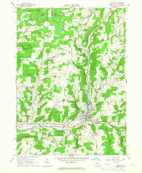
1965 Map of Andover
USGS Topo · Published 1967About this map
The village of Andover serves as the central hub of this mid-1960s survey, situated at the confluence of the Erie-Lackawanna railroad and the waters of Dyke Creek. The landscape transitions from the developed valley floor to the forested high ground of the State Reforestation Area, revealing a region shaped by both industry and conservation. Numerous small family or community burial grounds, such as Hillside Cem and Valley Brook Cem, are scattered near the village, providing specific points of interest for genealogists tracing local families. To the south and west, the economy of the era is evidenced by active Oil Wells and Gravel Pits, while the hamlet of Elm Valley marks the western approach along Elm Valley Road. The inclusion of Foster Lake and Andover Pond highlights the importance of managed water resources in this part of Allegany County.
Find a feature on this map
38 named features on this map. Tap any name to fly to it.
Don’t see what you’re looking for? This feature index may not catch every label — zoom into the map to look around manually.
Map Details
Editions of this 1965 Andover Map
2 editions found
Other maps of this area

1915 · Hornell
USGS Topo · 1:62,500

1916 · Canaseraga
USGS Topo · 1:62,500

1918 · Hornell
USGS Topo · 1:62,500

1926 · Wellsville
USGS Topo · 1:62,500

1926 · Greenwood
USGS Topo · 1:62,500

1940 · Canaseraga
USGS Topo · 1:62,500

1950 · Elmira
USGS Topo · 1:250,000

1958 · Elmira
USGS Topo · 1:250,000

1962 · Elmira
USGS Topo · 1:250,000
1964 · Alfred
USGS Topo · 1:24,000