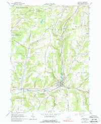
1965 Map of Andover
USGS Topo · Published 1988About this map
Andover serves as the focal point of this mid-1960s survey, where the Erie-Lackawanna railroad follows the valley of Dyke Creek past a series of established community landmarks. The settlement pattern is defined by the steep terrain of the Allegheny Plateau, with homes and industry clustered in the narrow corridors of Elm Valley and East Valley. Local history is deeply etched into the landscape through a significant concentration of burial grounds, including Hillside Cem, Valley Brook Cem, and Gate of Heaven Cem.
Find a feature on this map
41 named features on this map. Tap any name to fly to it.
Don’t see what you’re looking for? This feature index may not catch every label — zoom into the map to look around manually.
Map Details
Editions of this 1965 Andover Map
2 editions found
Other maps of this area

1915 · Hornell
USGS Topo · 1:62,500

1916 · Canaseraga
USGS Topo · 1:62,500

1918 · Hornell
USGS Topo · 1:62,500

1926 · Wellsville
USGS Topo · 1:62,500

1926 · Greenwood
USGS Topo · 1:62,500

1940 · Canaseraga
USGS Topo · 1:62,500

1950 · Elmira
USGS Topo · 1:250,000

1958 · Elmira
USGS Topo · 1:250,000

1962 · Elmira
USGS Topo · 1:250,000
1964 · Alfred
USGS Topo · 1:24,000