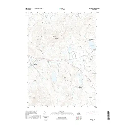
2018 Map of Andover
USGS Topo · Published 2018About this map
The Blackwater River carves a central path through this Merrimack County landscape, anchoring the historic villages of Andover, Potter Place, and Cilleyville. The settlement pattern follows the river valley and the path of the old northern railroad line, while the terrain rises sharply toward the Ragged Mountains in the north and the northern slopes of Mt Kearsarge in the south. Notable local landmarks include the Keniston Bridge and the Cilleyville Bridge, which reflect the region's traditional engineering heritage. High-elevation features like The Pinnacle and The Bulkhead define the northern ridges, overlooking numerous water bodies such as Bradley Lake and Highland Lake. This survey illustrates a quintessential New England balance of concentrated village centers and expansive upland forest, preserved through decades of topographic study.
Find a feature on this map
82 named features on this map. Tap any name to fly to it.
Don’t see what you’re looking for? This feature index may not catch every label — zoom into the map to look around manually.
Map Details
Editions of this 2018 Andover Map
This is the sole edition of this map. No revisions or reprints were ever made.
Other maps of this area

1925 · Holderness
USGS Topo · 1:62,500

1927 · Penacook
USGS Topo · 1:62,500

1927 · Holderness
USGS Topo · 1:62,500

1927 · Cardigan
USGS Topo · 1:62,500

1928 · Mount Kearsarge
USGS Topo · 1:62,500

1930 · Cardigan
USGS Topo · 1:62,500

1931 · Mount Kearsarge
USGS Topo · 1:62,500

1949 · Portland
USGS Topo · 1:250,000

1956 · Cardigan
USGS Topo · 1:62,500

1956 · Penacook
USGS Topo · 1:62,500