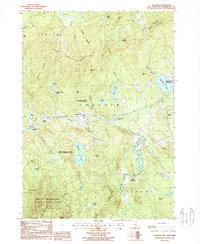
1987 Map of Andover
USGS Topo · Published 1987About this map
Andover and its surrounding hamlets sit at the center of this 1980s landscape, where the Blackwater River winds through a valley defined by prominent peaks. The map details a period of transition for rural Merrimack County, showing the proximity of conserved lands like Mount Kearsarge State Forest Park and Ragged Mountain State Forest to established settlements. Local history is preserved in the naming of smaller communities such as Cilleyville and Potter Place, while East Andover hints at the area's older rail connections. Water dominates the eastern and western edges, from the expansive Highland Lake to the secluded Bradley Lake. The presence of the Ragged Mountain Club and the Mount Kearsarge State Wildlife Management Area underscores the region's long-standing character as a hub for outdoor recreation and forestry management.
Find a feature on this map
47 named features on this map. Tap any name to fly to it.
Don’t see what you’re looking for? This feature index may not catch every label — zoom into the map to look around manually.
Map Details
Editions of this 1987 Andover Map
This is the sole edition of this map. No revisions or reprints were ever made.
Other maps of this area

1925 · Holderness
USGS Topo · 1:62,500

1927 · Penacook
USGS Topo · 1:62,500

1927 · Holderness
USGS Topo · 1:62,500

1927 · Cardigan
USGS Topo · 1:62,500

1928 · Mount Kearsarge
USGS Topo · 1:62,500

1930 · Cardigan
USGS Topo · 1:62,500

1931 · Mount Kearsarge
USGS Topo · 1:62,500

1949 · Portland
USGS Topo · 1:250,000

1956 · Cardigan
USGS Topo · 1:62,500

1956 · Penacook
USGS Topo · 1:62,500