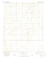
1978 Map of Andrix
USGS Topo · Published 1979About this map
Andrix serves as the primary focal point of this 1970s survey, situated along a prominent east-west thoroughfare in the high plains of Las Animas County. The settlement is anchored by a local Cem and sits at a crossroad of historic transit and ranching activity. The landscape is defined by the ephemeral drainages of Mustang Creek and O U Creek, which cut through the terrain and are fed by scattered Spring and Springs locations. Traces of the frontier era persist through the marked Granada Santa Fe Trail crossing the northern portion of the quadrangle, while modern utility is represented by several Well sites and a network of unimproved roads and a Jeep Trail. This map provides a detailed view of the rural infrastructure and land divisions that shaped this part of Colorado long after the initial homesteading era.
Find a feature on this map
9 named features on this map. Tap any name to fly to it.
Don’t see what you’re looking for? This feature index may not catch every label — zoom into the map to look around manually.
Map Details
Editions of this 1978 Andrix Map
2 editions found
Other maps of this area

1892 · Mt Carrizo
USGS Topo · 1:125,000

1955 · La Junta
USGS Topo · 1:250,000

1958 · La Junta
USGS Topo · 1:250,000

1968 · La Junta
USGS Topo · 1:250,000

1978 · Pintada Creek
USGS Topo · 1:24,000

1978 · Utleyville
USGS Topo · 1:24,000
1978 · Robbers Roost Canyon
USGS Topo · 1:24,000
1978 · Table Mesa
USGS Topo · 1:24,000
1978 · Buck Canyon
USGS Topo · 1:24,000
1978 · Carrizo Mountain
USGS Topo · 1:24,000