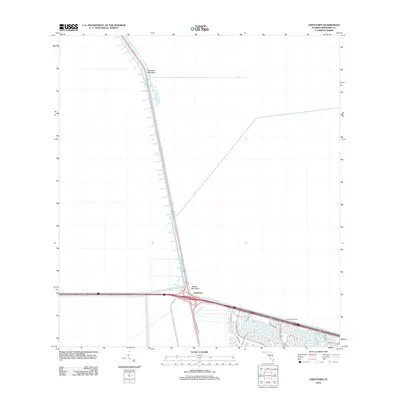
2012 Map of Andytown
USGS Topo · Published 2012About this map
Andytown serves as a critical junction point where major transport arteries meet the engineered water management systems of Broward County. Located at the intersection of the North New River Canal and major roadway corridors like W State Road 84, this area illustrates the modern transition from the vast natural Everglades toward planned residential developments. To the east, the landscape shifts abruptly into structured communities defined by winding suburban streets such as Glades Pkwy, Presidio Dr, and Indian Trce.
Find a feature on this map
14 named features on this map. Tap any name to fly to it.
Don’t see what you’re looking for? This feature index may not catch every label — zoom into the map to look around manually.
Map Details
Editions of this 2012 Andytown Map
This is the sole edition of this map. No revisions or reprints were ever made.
Other maps of this area

1956 · West Palm Beach
USGS Topo · 1:250,000

1957 · West Palm Beach
USGS Topo · 1:250,000

1958 · West Palm Beach
USGS Topo · 1:250,000

1963 · Andytown
USGS Topo · 1:24,000

1963 · Cooper City SW
USGS Topo · 1:24,000

1963 · Fort Lauderdale 2 SE
USGS Topo · 1:24,000
1963 · Cooper City NE
USGS Topo · 1:24,000
1963 · Cooper City
USGS Topo · 1:24,000

1973 · Everglades 4 NE
USGS Topo · 1:24,000

1973 · Everglades 4 SE
USGS Topo · 1:24,000