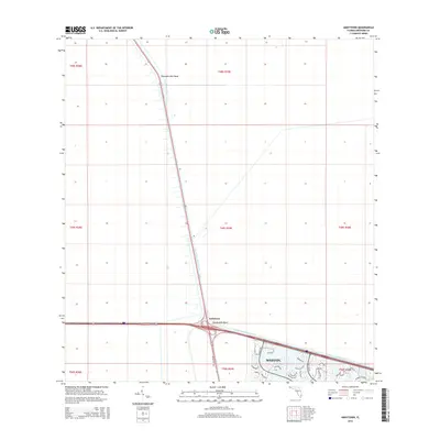
2015 Map of Andytown
USGS Topo · Published 2015About this map
Andytown and the modern residential expansion of Weston occupy this landscape at the intersection of major South Florida transportation corridors. The map highlights the geometry of the North New River Canal, which cuts a straight path through the Everglades terrain, punctuated by historic waterway markers like Twentysix Mile Bend and Twenty-Mile Bend. While the northern and western sections of the map remain largely open, defined by township and range lines like t49s r39e, the southeastern corner shows a dense network of suburban development. Here, intricately planned neighborhoods featuring Savannah Falls and Cedar Falls Dr represent the push of urbanization into once-remote marshlands. The convergence of Interstate 75 and US Highway 27 serves as the primary engine for this growth, transforming the area from a canal-side stop into a residential hub.
Find a feature on this map
34 named features on this map. Tap any name to fly to it.
Don’t see what you’re looking for? This feature index may not catch every label — zoom into the map to look around manually.
Map Details
Editions of this 2015 Andytown Map
This is the sole edition of this map. No revisions or reprints were ever made.
Other maps of this area

1956 · West Palm Beach
USGS Topo · 1:250,000

1957 · West Palm Beach
USGS Topo · 1:250,000

1958 · West Palm Beach
USGS Topo · 1:250,000

1963 · Andytown
USGS Topo · 1:24,000

1963 · Cooper City SW
USGS Topo · 1:24,000

1963 · Fort Lauderdale 2 SE
USGS Topo · 1:24,000
1963 · Cooper City NE
USGS Topo · 1:24,000
1963 · Cooper City
USGS Topo · 1:24,000

1973 · Everglades 4 NE
USGS Topo · 1:24,000

1973 · Everglades 4 SE
USGS Topo · 1:24,000